Day 1: Delhi to Shimla (365 Kms 10 Hrs.)
On arrival in Delhi Railway station or Airport you will meet and assist by our representative and drive to Shimla. On the way visit Pinjore Garden, Timber Trail. On arrival check in hotel. Dinner at hotel. Overnight stay in Shimla.
Day 2: Shimla Sightseeing
After breakfast Excursion to Kufri. Kufri is famous for its Himalayan National Park, Poney and Yak Ride and One can see the endless Himalayan Panorama from Kufri, after lunch sightseeing of various places in and around. Shimla mosques built in (1830), Vice regal Lodge built in (1885), Christ Church built in (1844), The Gaiety Theatre- the first beauty contest of world was supposed to start (1887), The Grind lays Bank (1912)- the world wide bank started by Robert Melville Grind lay, The Scandal Point and The famous Shopping Plaza of the North The Mall. Dinner at hotel. Overnight stay in Shimla.
Day 3: Shimla to Manali (265 Kms 8 Hrs.)
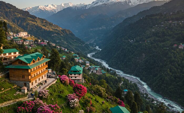
After breakfast checkout from the hotel & proceed to Manali. Its Placed at an altitude of 2050 m above the sea level, Manali is a very popular hill station that is flocked by tourists every year in crazy numbers. On reaching, check-in at the hotel. Get some rest. The evening is at leisure. Take a walk on main market road of Manali, Enjoy the cool breeze and more. Dinner at hotel and overnight stay in Manali.
Day 4: Manali Sigthseeing
Today after breakfast get all set for visiting the prime attractions of Manali, visit Hadimba temple, Manu temple, Vashisht Bath, Van Vihar, Tibetan Monastery, Club House back to hotel, Dinner at hotel, overnight stay in Manali
Day 5: Manali Sigthseeing
Manali After breakfast visit Solang valley, it is renowned as the preferred location for adventure activities in Himachal Pradesh. For those who love the rush of adrenaline; there is no place better than Solang in Kullu Valley to indulge in parachuting, paragliding, skating and zorbing (adventure activities are at your own cost). Solang is not just about adventure activities. Its lush greenery, apple orchards, snowcapped peaks and lakes attracts lakhs of visitors, later back to hotel, dinner at hotel, overnight stay in Manali.
Day 6: Manali to Chandigarh (320 Kms 10 Hrs.)
After breakfast check out hotel depart for Chandigarh. On the way visit Kullu Vaishno Devi Temple, Kullu shawl weaving Ind . Chandigarh is the 1st planned modern city of India designed by the French architect Le Corbusier. The city was named after the mother goddess of power, Chandi, whose temple Chandimandu is a feature of the new city. On arrival check in hotel. Dinner at hotel. Overnight stay in Chandigarh
Day 7: Chandigarh to Delhi (250 Kms 5 Hrs.)
After breakfast check out hotel & visit rose garden, rock garden, Sukhna lake, later depart to Delhi, on arrival drop at airport or railway station.
i.e. Standard / Deluxe / Super Deluxe / 3 Star / 4 Star / 5 Star, etc.
i.e. Standard / Deluxe / Super Deluxe / 3 Star / 4 Star / 5 Star, etc.
Himachal Pradesh (literally “Snow-laden Province”) is a state of India located in Northern India. It is bordered by Jammu and Kashmir on the north, Punjab and Chandigarh on the west, Haryana on the south-west, Uttarakhand on the south-east and by the Tibet Autonomous Region on the east. Hima means snow in Sanskrit, and the literal meaning of the state’s name is “in the lap of the Himalayas.” It was named by Acharya Diwakar Datt Sharma, one of the most eminent Sanskrit scholars of Himachal Pradesh.
Himachal Pradesh is famous for its natural beauty, hill stations, and temples.Himachal Pradesh has been ranked fifteenth in the list of the highest per capita incomes of Indian states and union territories for year 2013-14.Many perennial rivers flow in the state, and numerous hydroelectric projects set up. Himachal produces surplus hydroelectricity and sells it to other states such as Delhi, Punjab, and Rajasthan.[10] Hydroelectric power projects, tourism, and agriculture form important parts of the state’s economy.
The state has several valleys,and more than 90% of the population living in rural areas. Practically all houses have a toilet and 100% hygiene has been achieved in the state. The villages have good connectivity with roads, public health centres, and now with high-speed broadband.
Shimla district has maximum urban population of 25%. It has incorporated environmental protection and tourism development has been aided with a government ban on the use of polyethylene bags, reducing litter, and tobacco products, to aid people’s health. According to a 2005 Transparency International survey, Himachal Pradesh was ranked the second-least corrupt state in the country, after Kerala.
Himachal is in the western Himalayas. Covering an area of 55,673 square kilometres (21,495 sq mi), it is a mountainous state. Most of the state lies on the foothills of the Dhauladhar Range. At 6,816 m Reo Purgyil is the highest mountain peak in the state of Himachal Pradesh.
The drainage system of Himachal is composed both of rivers and glaciers. Himalayan rivers criss-cross the entire mountain chain. Himachal Pradesh provides water to both the Indus and Ganges basins.[20] The drainage systems of the region are the Chandra Bhaga or the Chenab, the Ravi, the Beas, the Sutlej, and the Yamuna. These rivers are perennial and are fed by snow and rainfall. They are protected by an extensive cover of natural vegetation.
Due to extreme variation in elevation, great variation occurs in the climatic conditions of Himachal . The climate varies from hot and subhumid tropical in the southern tracts to, with more elevation, cold, alpine, and glacial in the northern and eastern mountain ranges.The state has areas like Dharamsala that receive very heavy rainfall, as well as those like Lahaul and Spiti that are cold and almost rainless. Broadly, Himachal experiences three seasons: summer, winter, and rainy season. Summer lasts from mid-April till the end of June and most parts become very hot (except in the alpine zone which experiences a mild summer) with the average temperature ranging from 28 to 32 °C (82 to 90 °F). Winter lasts from late November till mid March. Snowfall is common in alpine tracts (generally above 2,200 metres (7,218 ft) i.e. in the higher and trans-Himalayan region).
5,520.3 km2 (5,992.4 sq mi) in area. The Himalayas divide the Kashmir valley from Ladakh while the Pir Panjal range, which encloses the valley from the west and the south, separates it from the Great Plains of northern India. Along the northeastern flank of the Valley runs the main range of the Himalayas. This densely settled and beautiful valley has an average height of 1,850 metres (6,070 ft above sea-level but the surrounding Pir Panjal range has an average elevation of 5,000 metres (16,000 ft).Because of Jammu and Kashmir’s wide range of elevations, its biogeography is diverse.Northwestern thorn scrub forests and Himalayan subtropical pine forests are found in the low elevations of the far southwest. These give way to a broad band of western Himalayan broadleaf forests running from northwest-southeast across the Kashmir Valley. Rising into the mountains, the broadleaf forests grade into western Himalayan subalpine conifer forests. Above the tree line are found northwestern Himalayan alpine shrub and meadows. Much of the northeast of the state is covered by the Karakoram-West Tibetan Plateau alpine steppe. Around the highest elevations, there is no vegetation, simply rock and ice.
Srinagar- Yatra- Hindu holy cave
Division Area km2 Percentage Area
Kashmir 15,948 15.73%
Jammu 26,293 25.93%
Ladakh 59,146 58.33%
India-administrated Jammu and Kashmir 101,387 km2 100%.
The Jhelum River is the only major Himalayan river which flows through the Kashmir valley. The Indus, Tawi, Ravi and Chenab are the major rivers flowing through the state.
Jammu and Kashmir is home to several Himalayan glaciers with an average altitude of 5,753 metres (18,875 ft) above sea-level, the Siachen Glacier is 76 km (47 mi) long making it the longest Himalayan glacier.
The climate of Jammu and Kashmir varies greatly owing to its rugged topography. In the south around Jammu, the climate is typically monsoonal, though the region is sufficiently far west to average 40 to 50 mm (1.6 to 2 inches) of rain per month between January and March. In the hot season, Jammu city is very hot and can reach up to 40 °C (104 °F) whilst in July and August, very heavy though erratic rainfall occurs with monthly extremes of up to 650 millimetres (25.5 inches). In September, rainfall declines, and by October conditions are hot but extremely dry, with minimal rainfall and temperatures of around 29 °C (84 °F).
Across from the Pir Panjal range, the South Asian monsoon is no longer a factor and most precipitation falls in the spring from southwest cloudbands. Because of its closeness to the Arabian Sea, Srinagar receives as much as 635 millimetres (25 in) of rain from this source, with the wettest months being March to May with around 85 millimetres (3.3 inches) per month. Across from the main Himalaya Range, even the southwest cloudbands break up and the climate of Ladakh and Zanskar is extremely dry and cold. Annual precipitation is only around 100 mm (4 inches) per year and humidity is very low. In this region, almost all above 3,000 metres (9,750 ft) above sea level, winters are extremely cold. In Zanskar, the average January temperature is -20 °C (-4 °F) with extremes as low as -40 °C (-40 °F). All the rivers freeze over and locals make river crossings during this period because their high levels from glacier melt in summer inhibits crossing. In summer in Ladakh and Zanskar, days are typically a warm 20 °C (68 °F), but with the low humidity and thin air nights can still be cold.
Join our newsletter for trip ideas sent to your inbox.


Secure & trusted payment options